Bruges as it stood in 1562

The town rebuilt street by street from heritage records, measured buildings and archives. Every street, canal and house plot lies where it lay. You walk through it in your browser.

Chrome or Edge on a computer. Which computers?

You are reading this on a phone or tablet. The city itself needs a computer, so have a look round here and open it later at a desk.

houses on their real plots
2,772
landmarks modelled one by one
133
streets and quays by name
147
hectares of town to walk
68
sources cited in the history ledger
750

Trailer

One day in 1562

From dawn to dusk, filmed in the city. Music: Tielman Susato, Pavane La bataille (Danserye, Antwerp 1551), played by Musica3eso (CC BY-SA 3.0).

What this is

Bruges in the summer of 1562

Bruges 1562 reconstructs the town as it was in a single year. In the summer of 1562 Bruges had lost most of its sea trade to Antwerp, Sint-Donaas on the Burg had been a cathedral for three years, and the Waterhalle still stood over the canal on the east side of the Markt.

The model starts from what can be measured today. Streets, canals and plots come from the present-day map, because most of them have not moved in five centuries. Buildings that still stand are measured and stripped of what was added later. Buildings that are gone are rebuilt from what was recorded and drawn of them.

There is a story to follow in it, but the town comes first. You can also just walk.

How the reconstruction is made
Every street lies where it lay

The walkable part is about 68 hectares with 147 named streets and quays. Their width, their bends and the plots along them follow the surveyed map. Where a street was cut through or a row was pulled down after 1562, the old line is put back.

A walk from the Markt into a side street, filmed in the model.

Six towers to climb

You can go up the belfry, the towers of Onze-Lieve-Vrouw, Sint-Salvator, Sint-Jakob and the old Sint-Walburga, and the tower of the Poortersloge. Their heights are measured from the laser survey of Flanders, so the view from the top is the real one, with the roofs of 1562 under it.

The view from the belfry over the Markt.

Every landmark has its history

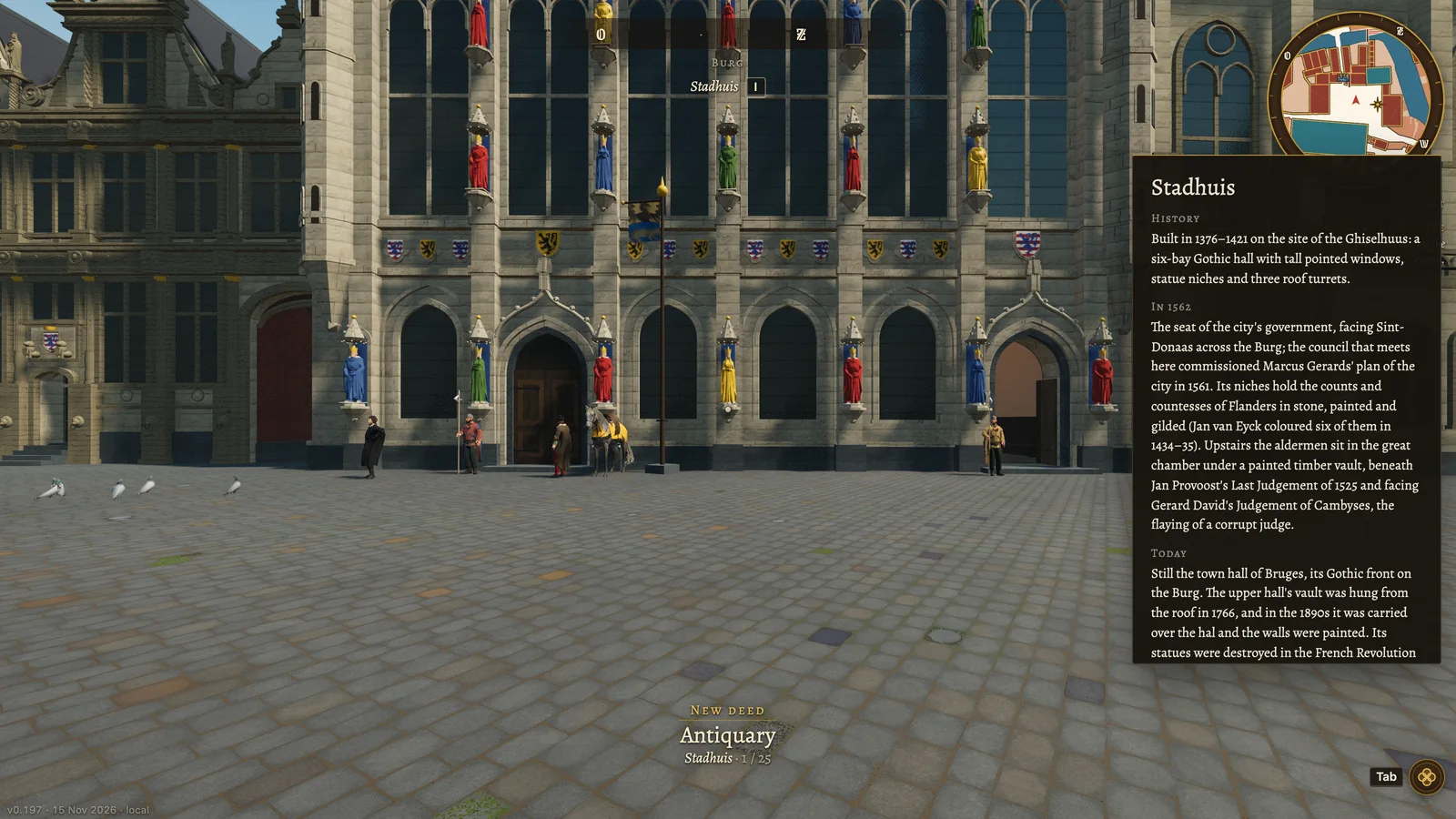
Look at a church, a hall, a bridge or a great house and press I. A card tells you how it came to be, how it stood in 1562 and what became of it. There are 133 such cards in this version, each written from a ledger entry with its sources. Where the sources stop, the card says so.

The front of the Stadhuis on the Burg in the model, with its history card open on the right
The Stadhuis on the Burg (1376–1421) with its card.

A story in sixteen chapters

Book I, Home to Bruges, begins as you walk out of the Steen, the town prison, after a week inside for something you did not do. Each chapter is built round one true thing of 1562: a building, an office, a trade. The people and their errands are invented, but the town they move in follows the sources.

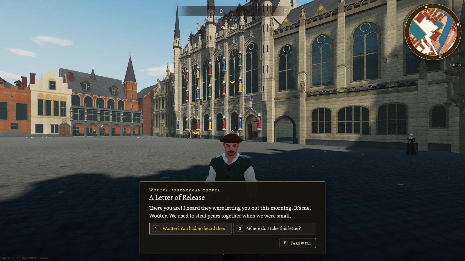
Wouter, a journeyman cooper, speaks to you on the Burg in front of the Stadhuis; his words and two answers are on screen
The first chapter: Wouter, a journeyman cooper, meets you on the Burg.

Deeds keep count of what you found

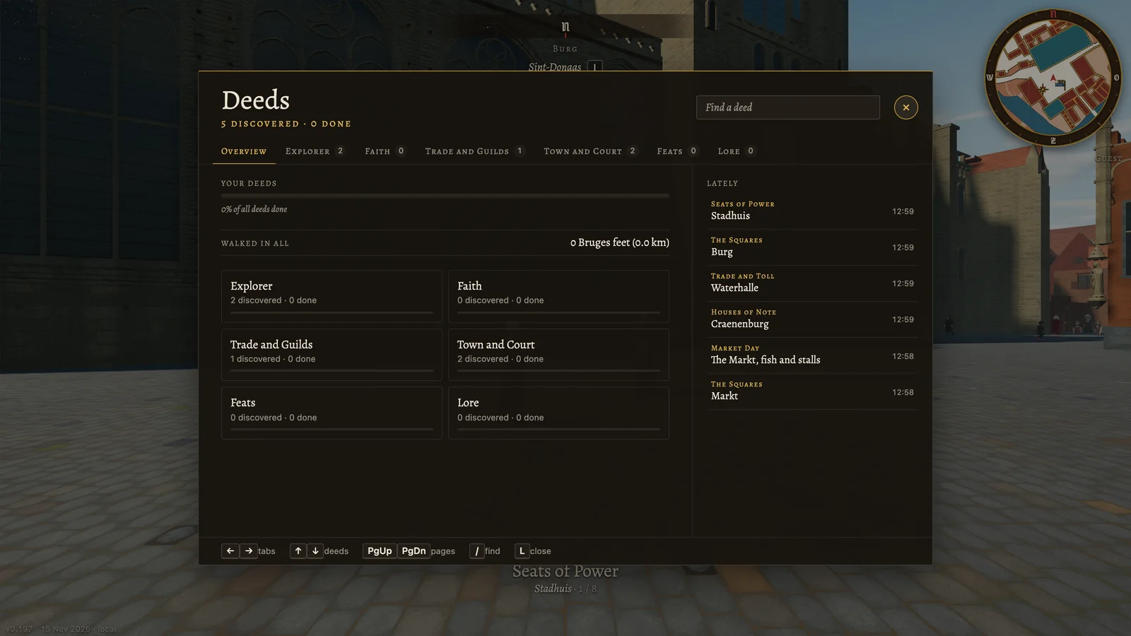
The deed log counts the squares you stood on, the churches and inns you went into, the towers you climbed and the cats you found in the narrow lanes. It also adds up how far you walked, in Bruges feet.

The deed log open over the street: six groups of deeds and a list of the last places found
The deed log after a first walk across the Markt and the Burg.

Getting around

On foot, on horseback or by boat

In the city

How it is made

Measured where it can be, sourced where it cannot

  1. The ground

    Streets, canals, bridges and house plots are imported from OpenStreetMap. The level of the ground comes from the Flemish laser height model, so a quay slopes to the water where the real one does.

  2. Landmarks, one by one

    Each of the 133 landmarks is placed on its outline from the heritage inventory of Onroerend Erfgoed. Ridge, eaves and tower heights are read from the laser survey, lower lines from photographs fitted to it. Anything added after 1562 is left off.

  3. What is gone

    Sint-Donaas was pulled down from 1799 and the Waterhalle from 1787. Buildings like these are rebuilt from excavation plans, written descriptions and old views. Old views give their form; their size comes from what was measured.

  4. Ordinary houses

    The 2,772 other houses are drawn on their real plots in the house types of the period: timber fronts, brick fronts, stepped gables. They are typical of 1562 and are not portraits of the houses that stood there.

  5. The ledger

    Every historical statement is an entry in a ledger: what stood there in 1562, how sure that is, where sources disagree, and the sources themselves. This version rests on 189 entries.

The town is history as far as the sources go and a careful guess where they stop. Interiors, the colour of a front and the people in the street are mostly guesses. The story is fiction.

Main sources: the heritage inventory of Onroerend Erfgoed, the Digital Height Model of Flanders, OpenStreetMap, the Bruges city archive, published studies, and the town plans of the 1560s by Jacob van Deventer and Marcus Gerards. The full list with licences is on the credits page.

Now and next

Version 1 is the heart of the town. The rest of the city is being built

In it now

  • The old town inside the first wall: the Markt, the Burg, the Dijver, Sint-Salvator, Onze-Lieve-Vrouw, Sint-Jakob, the Prinsenhof and the port at the Kraan.
  • 133 landmarks with a history card, six of them with a tower to climb.
  • Book I of the story in 16 chapters, and side errands.
  • Post horses, boats, a water taxi, the deed log and the town map.
  • The model itself in Dutch, English and French.

Being built

  • The rest of the city, quarter by quarter, out to the ramparts and the gates.
  • More interiors: more of the buildings you now only see from the street.
  • The next books of the story, which follow the new quarters.
  • Corrections, from the mistakes that visitors report.
  • Testing on more computers, and a lighter setting for modest ones.

What changed lately

Before you open it

It needs a computer and Chrome or Edge

The city is drawn with WebGPU. It works well on a laptop or desktop from the last four or five years with a decent graphics chip and 16 GB of memory. The download is about 85 MB and the first load takes around 40 seconds on a recent laptop. Phones, tablets and Safari do not work yet.

The full table of computers and browsers

Questions

Asked often

What is Bruges 1562?

A 3D model of the city of Bruges as it stood in the year 1562, reconstructed street by street from sources. It opens in a web browser and you walk through it at eye height.

Is it a game?

It is a historical model first. Inside it there is a story in 16 chapters, a log of deeds, horses and boats, so it also plays as a game. Nothing forces you to follow the story.

How accurate is it?

The street plan, the plots, the position and the heights of the landmarks are measured. What stood where in 1562 follows the heritage inventory and published history, entry by entry. The fronts of ordinary houses are typical of the period and are not individual portraits. Interiors and colours are often reconstructions, and the history cards say where that is so.

Is it finished?

No. The heart of the town inside the first city wall is there. The rest of the city, more interiors and more of the story are being built.

How do I get in?

With an access code. Put your name on the waiting list and you get one by mail.

Which computer do I need?

A laptop or desktop from the last four or five years with a decent graphics chip and 16 GB of memory, with a current Chrome or Edge. It has been tested on few machines so far. The table on the Help page says what is known.

Does it work on a phone or tablet?

Not yet. The city is too heavy for them and it is walked with a keyboard and a mouse.

I found a mistake. Where do I report it?

In the city, press F on the spot and the report carries the place with it. Anything else goes through the feedback page. Add a source for the correction if you have one.

Start on the Burg and keep walking

Put your name on the waiting list and a code follows by mail.